Aspirational Trails Map of Greater PW County
Where do Prince William County and the Cities Need to Add Trails? Tell us!
The map at https://arcg.is/ev9rv
is a draft proposal of trails (including shared use paths, sidewalk connections, bike routes, blueways, and even horse trails) that could be built over the next 20-30 years in Manassas, Manassas Park, and Prince William County. This map also serves as a tool to consolidate and validate existing data about trails.

What is the Aspirational Trails Map?
The map at https://arcg.is/ev9rv
is a draft proposal of trails (including shared use paths, sidewalk connections, bike routes, blueways, and even horse trails) that could be built over the next 20-30 years in Manassas, Manassas Park, and Prince William County. This map also serves as a tool to consolidate and validate existing data about trails.
Existing trails are not adequate. Plans for trails adopted by Manassas, Manassas Park, Prince William County, Dumfries, Haymarket, Occoquan and Quantico are not adequate. Too many gaps remain between planned trail segments, so the Aspirational Trails Map is intended to close those gaps.
The Aspirational Trails Map is a key step to implement the vision of the Greater Prince William Trails Coalition to create “A scenic, sustainable, and connected multi-modal trail system for greater Prince William County that enhances quality of life by providing equitable access to transportation, recreation, cultural, educational, and economic opportunities for all.”
The trails map is intended to identify opportunities to enhance trails for recreational opportunities, healthy exercise, tourism, and “mobility.”
Mobility or “active transportation” includes walking and biking for transportation – getting from home to work, retail stores, worship centers, and public facilities such as schools, parks, libraries without having to drive in a car.


Who created it?
The Greater Prince William Trails Coalition is leading the effort to create the map, and to get public input to improve the current draft.
The Coalition was organized formally in early 2020 to create a communications forum among organizations that care about trails in our region. The National Park Service and the Prince William County Department of Parks, Recreation and Tourism initiated the effort, and a National Park Service grant has been key to getting technical mapping assistance from the Center for Community GIS.
About 25 organizations are now members of the Coalition – see https://www.gpwtrails.org/
for more details.
Mission statement: “The Coalition convenes a network of diverse partners to preserve and enhance greater Prince William County’s trails and blueways, coordinate trail development efforts, prioritize key county-wide trail projects, and enhance public life by connecting communities.“
Members of the Coalition include “Advisors” and “Partners.” Advisors are the government agencies planning and managing trails. Partners include businesses and non-government organizations which support improving the network of trails.
The Advisors, staff from government agencies, participate in meetings and share ideas/plans. However, as government employees they can not lobby elected officials for funding or setting priorities.
In contrast, Partners are advocates who engage with elected officials in the planning and budgeting decisions. Partners have the flexibility to advocate for funding to plan and implement a high-quality trails network.
The Coalition is a volunteer effort, not a government organization. The Coalition has no dues, no budget, and no staff. It serves as a catalyst for change and as a forum for coordination and collaboration, but has no official authority or resources to actually implement a proposed trails network.
Why was the Aspirational Trails Map created in 2021?
The Coalition became an effective organization in 2020, with a clear understanding of how collaboration could be directed towards creating on-the-ground trail connections and improvements.
Discussions about gaps in existing trails, and missed opportunities to create trails as roads were widened or new developments were approved, led to an obvious action plan:
1) identify where it was appropriate and feasible to improve the current trails network
2) create a map showing a proposed trails network, recognizing that it could require several decades to implement
3) get community endorsement of proposed trails improvements, especially those that require permission to cross land owned by Home Owner Associations (HOAs) or acquisition of land/easements to allow public use
4) organize a critical mass of organizations and citizens to encourage elected officials to plan and fund trail improvements over the next 20-30 years
We are still in Step #1. On April 15, the Coalition released the first draft, draft, draft version of an Aspirational Trails Map. The April 15 draft provided the starting point for discussion with various organizations, community groups, businesses, and individuals on “appropriate and feasible” opportunities to improve the current trails network.
How will the Aspirational Trails Map be used?
The April 15 draft reflected ideas of members of the Coalition. That draft will be used to get community input in order to refine the proposal.
Members of the Coalition are now seeking opportunities to meet with others for “show-and-listen” sessions. Feedback will, hopefully, allow for refinement of where to draw lines on the Aspirational Trails Map.
Many community discussions are still required before the Coalition can adopt a Proposed Trails Map. After incorporating feedback, Coalition will advance from “aspirational” to “proposed” map in Summer, 2021.
If we don’t ask for trails in a constructive way, with specific segments identified - we won’t get trails.
Prince William County, Manassas, Manassas Park, and the towns of Dumfries, Haymarket, Occoquan and Quantico have long-range Comprehensive Plans, Capital Improvement Programs (CIPs), and annual budgets. First step in getting a better trails network is to get the segments included in the Comprehensive Plans, followed by inclusion in the CIPs and finally authorization in annual budgets.
Aspiring, proposing, planning, budgeting, and advocating is the sequence for dreams/talk about a better trail network becoming a reality.
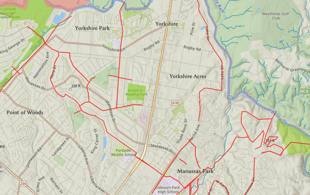
What is the meaning of different colored lines on the map?
Brown lines indicate existing trails, including paved shared use paths parallel to major highways and sidewalks in some cases.
Orange lines indicate trails planned by government agencies. Some are planned as a result of proffers included in rezonings for new development. In Prince William County, most orange lines are planned in Table 2 of the Transportation Chapter of the Comprehensive Plan. Those trails are linked to planned road widenings.
Red lines were added to map as “aspirational” additions to expand the trails network and close gaps.
What will happen to proposed updates?
The Coalition’s Steering Committee will refine the red lines now on the map, or proposed in ongoing discussions. More versions of the “aspirational” map will be produced, with the intention of reaching a consensus within the Coalition regarding what trails are appropriate and feasible.
In Summer 2021, Coalition is planning to adopt a “Proposed Trails Map” showing what new trails are recommended. In addition, Coalition is planning to identify priorities for building packages of trail segments in a logical sequence, and advocate at budget cycles for local government to fund those connections.
How can I propose updates?
1) Go to https://arcg.is/ev9rv
to see the Aspirational Trails Map.
2) Review lines on the map, recognizing they are draft and need revision. Brown lines show existing trails, orange lines show trails already planned by government agencies, and red lines show initial ideas/proposals for additional "aspirational" trails. A quick review will reveal there are duplications between lines of all three colors; this is a draft draft draft version now.
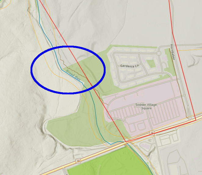
3) To comment on trails shown on draft map, click on a brown/orange line. Line will turn blue, and an attribute table will appear with (often incomplete) information about that segment.
4) Remember the ID and "Name" of that trail - in the example above, "G14" is the ID and "link Silver Lake-Leopold’s Preserve" is the Name shown in the attribute table.
5) Go to blue bar at top of Aspirational Trails Map and click on "Submit Trail Feedback." (In some browsers, may need to zoom down to just 75% in order to see the blue bar with "Submit Trail Feedback.")
6) Clicking on "Submit Trail Feedback" will take you to a comment page. Enter the "Name" of the trail, along with your other comments. Here is an example above.
7) If you want to add a new trail segment as an aspirational proposal, go to blue bar at top of Aspirational Trails Map and click on "Add Trail in Google Map."
Tutorial for that process is at https://drive.google.com/file/d/1GROVokQfCx85K45fQozArVZnaBhKhJG6/view
NOTE: Please make sure that any additional trail lines go into the “April/New – Aspirational Trails” Layer.